There is a vegetation management program in your utility spending heavily to keep trees clear of power lines, and the way it decides where to send crews is largely cyclical and manual: inspect on a schedule, trim what looks close. AI on satellite and LiDAR data promises to find the real encroachment risks across the whole network and prioritize crews by actual risk. An AI demo identified encroaching vegetation from imagery impressively. What the demo did not show is the data pipeline behind it, ingesting and processing massive satellite and LiDAR data across the network, and the prioritization that turns detections into a crew schedule that reduces risk and cost.
This is more than a detection model. It is AI vegetation management whose value rests on the data pipeline and prioritization, not the detection demo.
AI for vegetation management uses satellite and LiDAR data to identify encroachment risk, and its value is more than a detection model. It is a data pipeline that ingests and processes massive geospatial data across the network, detects and measures encroachment, and prioritizes crews by actual risk, turning detections into a schedule that reduces both outage risk and management cost. The detection is one component; the pipeline and prioritization deliver the value.
However, many programs are impressed by a detection demo and underbuild the pipeline and prioritization, discovering that detection without a pipeline and a crew schedule does not change the program.
If you are a utility or operations leader modernizing vegetation management, the intent of this article is:
- Define what AI vegetation management requires beyond detection
- Walk through the satellite/LiDAR pipeline and prioritization
- Lay out the controls a production deployment needs
To do that, let's start with the basics.
Healthcare Organization Made Data AI-Ready Seamlessly
An AI-ready data playbook for Chief Data Officers who need ROI inside the existing stack.
What Is AI Vegetation Management? The Basic Definition
At a high level, AI vegetation management is using AI on satellite and LiDAR data to detect and measure vegetation encroachment across a utility network and prioritize crews by actual risk, delivered through a data pipeline that processes massive geospatial data, not just a detection model.
To compare:
If a detection model is a sharp-eyed scout, AI vegetation management is the whole reconnaissance operation, the pipeline that surveys the entire network, measures the risks, and turns them into a prioritized patrol schedule. The scout spots a tree; the operation manages the network.
Why Is the Pipeline and Prioritization Necessary?
Issues that the pipeline and prioritization address or resolve:
- Processing massive satellite and LiDAR data across the network
- Turning detections into a risk-prioritized crew schedule
- Reducing outage risk and management cost together
Resolved Issues by the Pipeline and Prioritization
- Ingests and processes geospatial data at network scale
- Prioritizes crews by actual encroachment risk
- Replaces cyclical, manual scheduling with risk-based scheduling
Core Components of AI Vegetation Management
- Satellite and LiDAR data ingestion and processing
- Encroachment detection and measurement
- Risk-based prioritization
- A crew schedule from the prioritization
- Monitoring and accuracy in the field
Modern Vegetation Management Tooling
- Satellite and LiDAR data sources
- Geospatial processing pipelines
- Detection and measurement models
- Risk scoring and prioritization
- Field validation and feedback
These tools enable the program; the discipline is the pipeline and prioritization, not just detection.
Other Core Issues They Will Solve
- Reduce outage risk from vegetation
- Target crew spend at actual risk
- Provide network-wide visibility of encroachment
Importance of AI Vegetation Management in 2026
The pipeline and prioritization matter more as utilities modernize vegetation programs. Four reasons explain why it matters now.
1. Detection alone does not change the program.
A detection demo is impressive, but without a pipeline and a crew schedule, it does not change how the program operates.
2. The data is massive.
Satellite and LiDAR data across a network is enormous. Ingesting and processing it is a real pipeline problem.
3. Prioritization delivers the value.
Turning detections into a risk-prioritized crew schedule is what reduces outage risk and cost. That is the deliverable.
4. Cyclical scheduling wastes spend.
Cyclical, manual scheduling trims where it is not needed and misses real risk. Risk-based prioritization targets spend.
Traditional vs. AI Vegetation Management
- Cyclical, manual scheduling vs. risk-based prioritization
- Detection demo vs. a pipeline and crew schedule
- Schedule-driven trimming vs. risk-driven crew dispatch
- Local inspection vs. network-wide visibility
In summary: AI vegetation management processes satellite and LiDAR data at scale and prioritizes crews by risk, delivering a schedule that reduces risk and cost, not just a detection model.
Details About the Core Components of AI Vegetation Management: What Are You Designing?
Let's go through each layer.
1. Data Pipeline Layer
Processing the geospatial data.
Pipeline decisions:
- Satellite and LiDAR ingestion at network scale
- Geospatial processing
- Handling massive data volumes
2. Detection Layer
Finding encroachment.
Detection decisions:
- Encroachment detection and measurement
- Distance-to-line and growth assessment
- Accuracy on real imagery
3. Prioritization Layer
Turning detections into risk.
Prioritization decisions:
- Risk scoring by encroachment and consequence
- Prioritization across the network
- A risk-ranked work list
4. Scheduling Layer
Crews to work.
Scheduling decisions:
- A crew schedule from the prioritization
- Risk-based dispatch
- Cost and risk balanced
5. Field Layer
Validating and learning.
Field decisions:
- Field validation of detections
- Accuracy monitored in the field
- Feedback improving the models
Benefits Gained from the Pipeline and Prioritization
- Network-wide encroachment risk identified at scale
- Crews prioritized by actual risk, reducing risk and cost
- A schedule that changes how the program operates
How It All Works Together
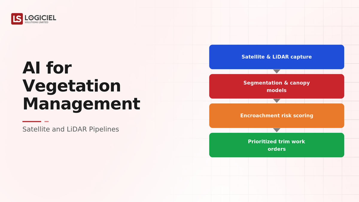
A data pipeline ingests and processes massive satellite and LiDAR data across the network, the real engineering behind the program. Detection models identify and measure encroachment, distance to lines and growth, on real imagery. The detections are scored for risk by encroachment severity and consequence and prioritized across the network into a risk-ranked work list. That prioritization becomes a crew schedule, dispatching crews by actual risk and balancing cost and risk, replacing cyclical, manual scheduling. Field validation confirms detections, accuracy is monitored in the field, and feedback improves the models. The program reduces both outage risk and management cost, because the value, the pipeline and prioritization, was built, not just the detection demo.
Common Misconception
A good vegetation detection model is the hard part.
Detection is one component. The pipeline that processes massive satellite and LiDAR data across the network and the prioritization that turns detections into a risk-based crew schedule are where the value and most of the engineering are. A detection model without them does not change the program.
Key Takeaway: The value is the pipeline and prioritization, not the detection demo. AI vegetation management changes the program when detections become a risk-prioritized crew schedule.
Real-World AI Vegetation Management in Action
Let's take a look at how the pipeline and prioritization operate with a real-world example.
We worked with a utility impressed by a detection demo, with these constraints:
- Process satellite and LiDAR data across the network
- Turn detections into a risk-prioritized crew schedule
- Reduce outage risk and management cost
Step 1: Build the Data Pipeline
Process the geospatial data.
- Satellite and LiDAR ingestion at scale
- Geospatial processing
- Massive volumes handled
Step 2: Detect and Measure
Find encroachment.
- Detection and measurement
- Distance-to-line and growth
- Accuracy on real imagery
Step 3: Prioritize by Risk
Rank the work.
- Risk scoring by encroachment and consequence
- Network-wide prioritization
- Risk-ranked work list
Step 4: Schedule Crews
Dispatch by risk.
- Crew schedule from prioritization
- Risk-based dispatch
- Cost and risk balanced
Step 5: Validate in the Field
Learn and improve.
- Field validation
- Accuracy monitored
- Feedback to models
Where It Works Well
- A pipeline processing satellite and LiDAR data at scale
- Risk-based prioritization into a crew schedule
- Field validation and accuracy monitoring
Where It Does Not Work Well
- A detection model with no pipeline or prioritization
- Cyclical scheduling unchanged by the detections
- No field validation of detections
Key Takeaway: The AI vegetation program that reduces risk and cost is the one with a pipeline and risk-based prioritization turning detections into a crew schedule, not the impressive detection demo.

Common Pitfalls
i) Stopping at detection
A detection demo without a pipeline and prioritization does not change the program. Build the pipeline and the crew schedule.
- Build the data pipeline
- Prioritize by risk
- Produce a crew schedule
ii) Underbuilding the pipeline
Satellite and LiDAR data is massive. Underestimating the pipeline leaves detection unusable at scale.
iii) No prioritization
Detections without risk-based prioritization do not change scheduling. Turn detections into a risk-ranked work list.
iv) No field validation
Detections unvalidated in the field carry unknown accuracy. Validate and feed back.
Takeaway from these lessons: Most AI vegetation programs underdeliver because they stop at detection, not because of the model. Build the pipeline, prioritize by risk, and validate in the field.
AI Vegetation Management Best Practices: What High-Performing Teams Do Differently
1. Build the pipeline, not just the model
Ingest and process massive satellite and LiDAR data at network scale. The pipeline is where most of the engineering is.
2. Prioritize by actual risk
Score detections by encroachment severity and consequence and prioritize across the network into a work list.
3. Produce a crew schedule
Turn the prioritization into a risk-based crew schedule that reduces outage risk and management cost.
4. Validate in the field
Confirm detections in the field, monitor accuracy, and feed back to improve the models.
5. Measure risk and cost reduction
Track the program's reduction in outage risk and management cost, the deliverable, not just detection accuracy.
Logiciel's value add is helping utilities build the satellite/LiDAR data pipeline, risk-based prioritization, and crew scheduling, so AI vegetation management reduces outage risk and cost rather than producing an impressive detection demo.
Takeaway for High-Performing Teams: Focus on the pipeline and prioritization. AI vegetation management changes the program when massive geospatial data becomes a risk-prioritized crew schedule, not when a model detects a tree.
Signals You Are Doing AI Vegetation Management Correctly
How do you know the program is sound? Not in detection accuracy, but in the pipeline and the schedule. Below are the signals that distinguish a program from a demo.
The pipeline processes at scale. The team ingests and processes satellite and LiDAR data across the network.
Detections are prioritized. The team scores and prioritizes detections by actual risk into a work list.
Crews are scheduled by risk. The prioritization becomes a crew schedule, replacing cyclical scheduling.
Detections are validated. The team validates detections in the field and monitors accuracy.
Risk and cost fall. The team can show reduced outage risk and management cost, the deliverable.
Adjacent Capabilities and Connected Work
This work does not exist in isolation. AI vegetation management depends on, and feeds into, several adjacent capabilities. Building one without thinking about the others is the most common scoping mistake.
In most utilities, vegetation management shares infrastructure with the geospatial and asset data systems, the data platform, and the field operations process. It shares capacity with data engineering, vegetation operations, and field crews. And it shares leadership attention with whatever the next grid-reliability initiative is on the roadmap. Naming these adjacencies upfront helps the program scope realistically and helps leadership see the work as a portfolio rather than a one-off project.
The most common mistake in adjacent-capability scoping is treating each adjacency as someone else's problem. The geospatial data the pipeline processes is your problem. The field operations the schedule drives are your problem. The field validation is your problem. Pretending otherwise pushes work to teams that did not plan for it, and the work returns to you later as a detection demo that changed nothing. Own the adjacencies you depend on; partner with the teams that own them; share the timeline.
Conclusion
AI for vegetation management uses satellite and LiDAR data to identify encroachment risk, and its value is in the data pipeline and risk-based prioritization that turn detections into a crew schedule reducing risk and cost. The discipline that delivers it is the same discipline behind any operational AI: build the pipeline, prioritize by risk, and act on the output.
Key Takeaways:
- The value is the pipeline and prioritization, not the detection demo
- Process massive satellite and LiDAR data and prioritize by actual risk
- Turn detections into a crew schedule and validate in the field
Doing AI vegetation management well requires pipeline, prioritization, and field discipline. When done correctly, it produces:
- Network-wide encroachment risk identified at scale
- Crews prioritized by actual risk, reducing risk and cost
- A schedule that changes how the program operates
- Validated detections and measured risk-and-cost reduction
VP of Data Secured Modern Platform Funding
A funding playbook for VPs of Data who need a board to approve the next platform.
What Logiciel Does Here
If a vegetation detection demo impressed you, build the satellite/LiDAR pipeline, prioritize by actual risk, and turn detections into a crew schedule that reduces outage risk and cost.
Learn More Here:
- Data Pipelines for Sensor-Heavy Energy Workloads
- AI for Outage Management: Prediction, Restoration, and Communication
- Wildfire and Weather AI for Utilities: Risk Models in Production
At Logiciel Solutions, we work with utilities on AI vegetation management, geospatial pipelines, and risk-based prioritization. Our reference patterns come from production utility AI deployments.
Explore how to build AI vegetation management on satellite and LiDAR pipelines.
Frequently Asked Questions
What is AI for vegetation management?
Using AI on satellite and LiDAR data to detect and measure vegetation encroachment across a utility network and prioritize crews by actual risk, delivered through a data pipeline that processes massive geospatial data, not just a detection model. The value is in the pipeline and prioritization.
Isn't the detection model the hard part?
No. Detection is one component. The pipeline that ingests and processes massive satellite and LiDAR data across the network, and the prioritization that turns detections into a risk-based crew schedule, are where most of the engineering and the value are. Detection alone does not change the program.
How does AI vegetation management reduce cost?
By replacing cyclical, manual scheduling, which trims where it is not needed and misses real risk, with risk-based prioritization that dispatches crews by actual encroachment risk. This targets spend where it reduces outage risk, lowering both risk and management cost.
Why is the data pipeline a big deal?
Because satellite and LiDAR data across a utility network is enormous, and ingesting, processing, and analyzing it at scale is a substantial engineering problem. Underbuilding the pipeline leaves detection unusable across the network, so the pipeline is central, not incidental.
What is the biggest mistake in AI vegetation management?
Being impressed by a detection demo and underbuilding the pipeline and prioritization. A detection model without a network-scale pipeline and a risk-based crew schedule does not change how the program operates. Build the pipeline, prioritize by risk, produce a schedule, and validate in the field.